AVAILABLE 24x7
888.662.2724
AVAILABLE 24x7
(888) 66CARAH
Fast & Accurate
Request A Quote
Quick Response
Chat With Us

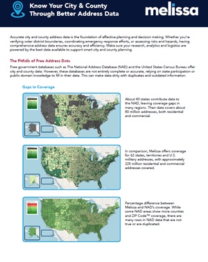
This datasheet shows how accurate city and county address data powers smarter planning, emergency response and community services. Unlike free government datasets that leave gaps and outdated records, Melissa provides verified coverage of 225 million U.S. addresses, delivering more completeness and detail than both the Census Bureau and NAD. With enriched insights like legislative districts, property data and rooftop-level geocoding, the datasheet highlights how Melissa helps agencies improve voter mapping, infrastructure planning and risk assessments with confidence. Seamless Esri and ArcGIS Pro integration ensures data is ready to drive immediate results.

Download the Resource