
Line 45 Solutions for the Public Sector
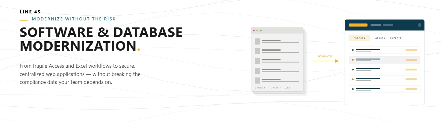
Software & Database Modernization
The Era of Spreadsheet-Based Regulation is Over
We specialize in replacing agencies’ legacy databases, disconnected desktop applications, and manual processes with modern web applications built for the future. Our custom solutions move you beyond the risks of MS Access and Excel and into a streamlined platform that secures data, simplifies compliance, and restores public confidence.
-
Improve Data Quality & Security
Transition your critical compliance data from error-prone spreadsheets and unsupported legacy systems into a centralized, secured, and version-controlled database engineered for reporting integrity and long-term stability.
-
Streamline Data Entry
Ensure that data is validated and correctly formatted upon entry, drastically reducing the amount of time your staff spends on reporting delays and data clean-up.
-
Empower Agency-Wide Data Access
Break down internal data silos by implementing a secure web-based portal that provides authorized staff—from field inspectors to executive directors—with immediate, reliable, and role-specific access to the single source of truth.
-
Accelerate Public Reporting and FOIA Requests
Dramatically reduce the time spent compiling and verifying public data requests. Our software can help you generate accurate, verifiable, and pre-formatted public-facing pages and reports.
-
Mitigate Operational Risk from Technical Debt
Proactively address the growing threat of system failure and obsolescence inherent in relying on unsupported desktop software and personal spreadsheets, securing your agency's mission with a stable, scalable, and maintainable platform.
-
Reallocate Valuable Staff Time to Mission-Critical Tasks
By automating repetitive data entry, validation checks, and manual report generation, your specialized staff can shift their focus from frustrating data management to high-value analytical work that directly serves the public and your agency's mission.
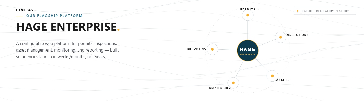
HAGE Enterprise (Regulatory software)
HAGE: Streamlining Your Agency's Compliance Data Lifecycle
HAGE Enterprise helps regulators collect and manage data. It can be configured for unique regulatory agency needs, but comes with a number of standard features that are especially well suited for agencies in the environmental and energy areas:
-
Streamlined External Data Submission
Provides a secure, dedicated portal for regulated entities to submit complex data via customizable web forms, supporting both manual input and efficient bulk uploads from common file types like Excel.
-
Compliance Workflow
Manages electronic submissions through a review workflow (Draft, Pending Review, Accepted, Rejected), migrating validated data into the agency's system of record upon approval.
-
Intuitive Data Management
Offers flexible, grid-based list pages and detailed record views for agency staff to efficiently browse, filter, trace relationships, and directly edit records.
-
Powerful Search and Custom Views
Features advanced filtering and quick-search functionality across all data sets, enabling users to define, save, and export customized data views to Excel for focused data analysis and reporting.
-
SQL-Driven Reporting
Allows administrative users to generate dynamic, SQL-backed reports for effective oversight without requiring application code changes.
-
Data Visualization
A map, graphs, and charts provide quick insights.
-
Modular and Integratable Design
Built with a flexible architecture, the application can be deployed as a complete end-to-end system, or selectively integrated as a dedicated intake or editing layer with existing applications and third-party solutions via APIs (application programming interfaces).
-
Multi-Tiered Security Model
Establishes granular access control by defining distinct roles (e.g., external users, internal reviewers, admin users), allowing the agency to precisely customize permissions for viewing, submitting, and editing specific data
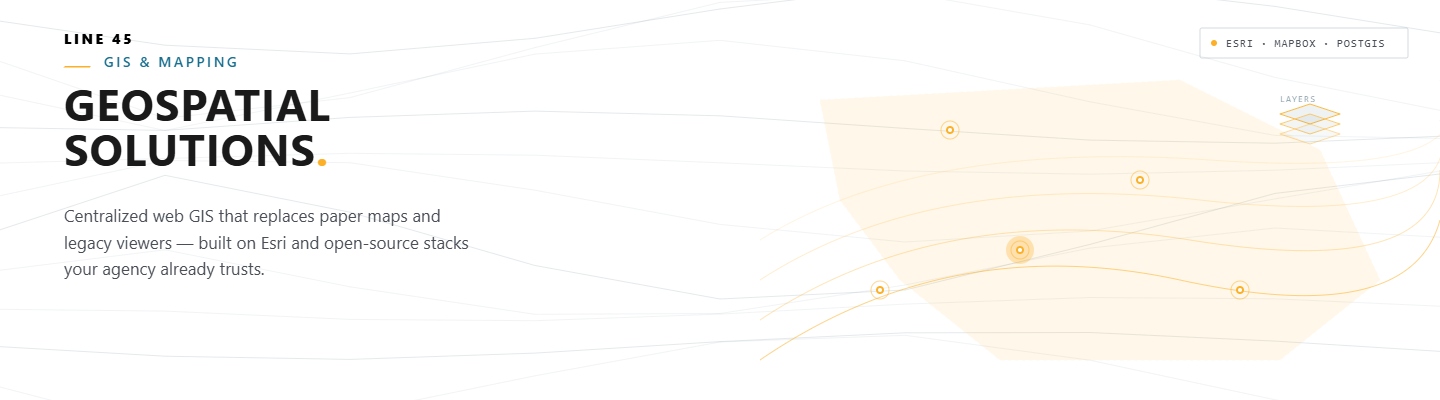
Geospatial Solutions
Move Beyond Static Maps to Dynamic Decision Tools
We transform fragmented paper maps and outdated spatial systems into a secure, collaborative, and centralized web-based GIS application, powered by the most reliable platforms—whether that’s leveraging your existing investment in Esri ArcGIS or deploying solutions built on flexible, open-standard OSGeo tools. Our custom mapping solutions provide your agency with a single, authoritative visual platform that integrates complex regulatory data, enabling faster decisions and unified spatial compliance management.
-
Platform Agnostic Strategy (Esri & Open Source)
We custom-build your solution to fit your technology roadmap, utilizing your Esri ArcGIS data and services where needed, or deploying robust, open-standard mapping components (e.g., PostGIS, Leaflet, QGIS) to ensure maximum flexibility and reduced licensing costs.
-
Secure, Centralized Spatial Authority
Retire the risk of using disparate, unsynchronized map files. We can help you establish a single, secure, web-accessible GIS platform, ensuring every staff member is viewing and acting on the same, current regulatory boundaries and environmental data.
-
Seamless Data and Map Integration
Integrate spatial data layers (parcels, waterways, regulatory zones) directly with non-spatial compliance records (permitting, inspection history) from your core database, providing immediate context for faster analysis and oversight.
-
Empower Field Inspection and Response
Equip field teams with real-time, mobile-responsive access to all necessary maps, site records, and regulatory layers, integrating seamlessly with common field apps or custom web applications for enhanced data capture.
-
Legacy Data Migration
Leverage our expertise as an Esri partner and OSGeo member to smoothly migrate valuable institutional knowledge from legacy systems (shapefiles, older databases) onto a scalable, enterprise-grade platform.
-
Cost-Effective Spatial Analysis
We deliver advanced spatial queries, proximity analysis, and complex buffering using cost-effective open-source technology. This provides sophisticated analytical power without requiring a full suite of specialized desktop licenses