
Bentley Systems Resources
Featured Blogs
Forecasting Resilience: How Atlas 14 Strengthens Stormwater and Sewer Design
October 17, 2025
What forward-leaning State and Local agencies are doing to turn risk into readiness.
Most of us in public works know exactly what the National Oceanic and Atmospheric Administration’s (NOAA) Atlas 14 is, where it is used and why it matters. What has changed lately is not the definition, it is the urgency.
From Insights to Intervention: Building Safer Roads with Smarter Data
September 26 2025
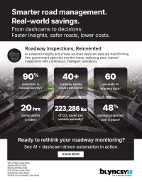
Safety threats do not always wait for the next inspection or make themselves obvious. A missing stop sign, a tilted guardrail or debris from a recent storm can pose real dangers long before a complaint is filed or a crash occurs. Near real-time visual data from crowd-sourced dashcam imagery allows agencies to detect these issues earlier, reducing the risk of collisions, confusion and liability.
More Coverage, Less Overhead: Rethinking Road Inspection Costs with AI-Driven Insights
August 18, 2025
Trying to make your maintenance dollars go further without cutting corners on insight, safety or service?
The End of Manual Inspections? How AI and Dashcam Imagery Are Redefining Roadway Management
July 30, 2025
Years ago, as I waited at a traffic light, I wondered why infrastructure maintenance still leaned so heavily on manual inspections and reporting. That question sparked an idea: What if roads could tell us when something was wrong?
Back to TopFeatured
 |
 |
 |
 |

 |
 |
 |
 |
 |
 |

 |
 |
 |
 |

 |


 |
 |
 |
 |
 |


|
|
|
|
|
|
|
|
|
|
|
|