
State and Local Government
As state and local agencies adopt drone technology, they gain critical advantages—enhanced emergency response visibility, improved infrastructure monitoring, efficient resource deployment, and faster incident assessment.
However, this technology introduces new operational challenges: unauthorized drone activity near critical facilities, coordination gaps between fire, police, and public works departments, liability concerns from undocumented flights, and evolving FAA compliance requirements.
Airspace Link's comprehensive airspace coordination platform provides the unified system needed to monitor local airspace, streamline multi-agency operations, and create a sustainable structure for community-based drone programs.
For IT leaders and security professionals, implementing a comprehensive drone management platform requires careful consideration of critical requirements that seamlessly integrate with existing city infrastructure while maintaining the highest standards of security and reliability
Airspace Link's integrated platform gives state and local agencies the operational visibility and coordination tools required to secure community airspace, manage emergency response flights, and establish scalable infrastructure for public safety aviation.
Airspace Link enables municipalities to deploy coordinated drone programs across police, fire, EMS, and public works departments, creating operational models that can be replicated across jurisdictions statewide.
Our platform integrates real-time situational awareness, automated compliance verification, cross-department mission coordination, and complete audit trail documentation—providing a unified system that supports every aspect of public safety drone operations.

City-Wide Safety Protocol Integration

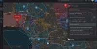
Airspace Activity Monitoring and Security
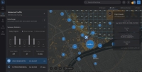
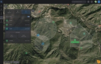
Complete Operational Visibility

Cross-Jurisdictional Coordination
Regulatory Compliance Architecture

Trusted and Secure
Comprehensive Audit Trail Management

Public Transparency
Cities Leading the Way in Drone Innovation
Let's Talk Smarter, Safer Operations Management
AirHub® Portal gives your agency the tools to coordinate airspace operations, ensure regulatory compliance, and enhance public safety. Speak with our public sector team today to explore solutions or schedule a live platform demonstration.