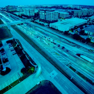
From Insights to Intervention: Building Safer Roads with Smarter Data

Safety threats do not always wait for the next inspection or make themselves obvious. A missing stop sign, a tilted guardrail or debris from a recent storm can pose real dangers long before a complaint is filed or a crash occurs. Near real-time visual data from crowd-sourced dashcam imagery allows agencies to detect these issues earlier, reducing the risk of collisions, confusion and liability.

This is not just about reacting to problems. It is about gaining continuous visibility across your road network. When you can see more, sooner, you prevent more and protect everyone who uses your roads.

Enable a Proactive Maintenance Culture

Proactive maintenance reduces risk by keeping infrastructure from reaching a failure point. It starts with awareness. With timely insights into pavement wear, fading striping or damaged safety features, you can fix problems before they become safety hazards.

Using this approach minimizes emergencies and reduces the need to send crews into high-risk, high-traffic situations. Over time, it is not just about saving money, it is about making safer and more intelligent decisions every day.

Do Not Let Blind Spots Become Risk Zones

Not every mile of the roadway gets equal attention. Areas that are not high-traffic or complaint-heavy can still hide dangerous issues, especially if they go uninspected for long periods.

Imagery from vehicles already on the road helps reveal what is often missed. It fills in the gaps between formal inspections, surfacing problems in places crews do not regularly visit.

Safety should not depend on luck or public reports. Every segment of your road network deserves consistent visibility.

Speed Recovery After Disasters

When a storm or crisis hits, minutes matter. Near real-time, image-based insights give agencies a fast way to assess damage and identify dangerous conditions, often before crews can access the scene.

Improved visibility enables quicker, more targeted responses. Agencies can clear routes, mark danger zones and stabilize infrastructure faster, protecting both the public and their crews.

The sooner you know what you are facing, the sooner you can act.

Awareness That Improves Safety Outcomes—Not Just Oversight

Effective safety programs do not rely on complaints, scheduled inspections or guesswork. They rely on data that reflects what is happening on the ground—frequently, consistently and with the scale to match the entire network.

Whether identifying early signs of pavement failure or responding to extreme weather events, increased awareness drives better outcomes: fewer emergencies, smarter spending and safer roads for all.

To learn how better information leads to safer roads, view Blyncsy’s portfolio.

More Coverage, Less Overhead: Rethinking Road Inspection Costs with AI-Driven Insights

Trying to make your maintenance dollars go further without cutting corners on insight, safety or service?

If so, you’re not alone. With budgets often stretched and infrastructure demands growing, many agencies are reexamining how to get the most value out of every maintenance dollar. That’s why many are rethinking expensive, labor-intensive field inspections and turning to smarter, more cost-effective alternatives.

AI-analyzed dashcam imagery from commercial and fleet vehicles gives teams near real-time, visual insights into road conditions without the typical overhead. By using what’s already on the road, agencies can cut spending while getting even better data on pavement conditions, signage, lane markings and hazards.

Smarter Inspections. Real Savings.

Manual inspections can cost anywhere from $100 to $200 per mile, depending on the method and crew required. When you factor in vehicle costs, staffing, scheduling and delays, those expenses scale fast, especially for agencies managing thousands of miles.

AI-powered visual intelligence can reduce up to 90% of the manual inspections traditionally required for roadway condition assessment. That’s a considerable savings in time and money. In Hawaii, automated analysis of guardrails, striping and debris saved the state DOT over $900,000 by eliminating unnecessary field visits and allowing more strategic deployment of maintenance dollars.

With continuous AI-driven assessments, inspections shift from rigid schedules to condition-based decision-making. This allows agencies to focus their limited resources where the data shows they’re actually needed, maximizing impact while minimizing waste.

Lower Operational Strain, Lower Spend

Reducing fieldwork doesn’t just save time, it cuts expenses across the board. Fewer field deployments mean lower fuel costs, less vehicle wear and fewer overtime hours.

Instead of organizing additional field inspections, agencies can rely on regularly updated insights coming from existing vehicle networks. This reduces the need to expand teams or invest in specialized equipment to keep up with inspections. It also supports a safer inspection process by reducing risk exposure for field crews.

Better visibility leads to more accurate budgeting. Instead of flying blind—or relying on complaints—you can plan maintenance with precision, stretch your resources and avoid surprise repairs that blow up budgets.

Faster Recovery, Lower Emergency Costs

Storms, floods, and other disruptions can incur urgent, unexpected expenses. But quick, AI-enabled visual assessments can help reduce emergency costs.

Agencies can assess road damage without dispatching field teams immediately, saving time and protecting crews. Infrastructure inspections are evolving to include tools like Google Street View, providing a reliable “before” snapshot. Combined with dashcam imagery for the “after,” agencies can clearly analyze damage and document changes over time. That early insight supports faster funding requests and avoids the cost of blanket response measures that may not be necessary.

With centralized, visual data that’s easy to share, teams can streamline contractor coordination, skip redundant inspections and focus their limited funds where they’ll have the most impact.

Rewriting the Cost Equation

Road inspections don’t have to drain your budget. With AI-analyzed dashcam data, agencies are expanding visibility across their networks while significantly cutting costs.

The real value lies in shifting from reactive to efficient, insight-driven decision-making. From daily maintenance to emergency recovery, this model is helping public teams rethink how, and how much, they spend on inspections.

For any agency trying to do more with the same—or even less—budget, it’s time to rethink how inspections are conducted.

Discover more cost-effective inspections today.

The End of Manual Inspections? How AI and Dashcam Imagery Are Redefining Roadway Management

Years ago, as I waited at a traffic light, I wondered why infrastructure maintenance still leaned so heavily on manual inspections and reporting. That question sparked an idea: What if roads could tell us when something was wrong?

Today, that vision has become a reality. Dashcam imagery—passively captured from vehicles already on the road—is now powering automated AI models that detect issues like fading lane paint, damaged signs, and debris. Looking ahead, the integration of expansive imagery sources, such as Google Street View, promises to further enhance this capability, offering broader and more detailed coverage. It’s a shift from scheduled inspections to constant awareness, from sending crews out to bringing insight in.

Automation with Real Impact

Traditional inspections are resource intensive. They usually involve deploying extra staff and specialized equipment, and scheduling work during off-hours to avoid disrupting traffic. AI-driven visual intelligence of dashcam footage can reduce the number of manual surveys required by more than 90%, saving considerable time and money.

Take Fort Worth. Dashcam imagery gave the city a fresh look at lane striping and sign visibility, but from the driver’s perspective, not an aerial map. It’s how people experience the road daily, and it’s the same view automated vehicles rely on to safely navigate.

Instead of waiting months for a full inspection cycle, cities can spot and act on issues within days. Enabling faster response and more strategic use of limited resources.

Smarter Operations. Less Fieldwork.

While field checks are still common for most agencies, the model is shifting. With dashcam footage collected by vehicles already in motion and analyzed automatically, teams can now monitor more of the network without constantly dispatching field crews.

In Alaska, for example, dashcam data is used to monitor remote routes that are difficult and sometimes dangerous for crews to inspect in person. This kind of visibility can be a game changer for regions with tough geography or tight budgets.

Instead of following a fixed schedule or responding to complaints, agencies can now rely on AI-driven alerts to flag when conditions change. It’s a shift from routine patrols to focused action, and it means fewer trips to the field, less fuel, and better outcomes with the same (or smaller) team.

Compliance without the Complexity

Staying compliant with FHWA, MUTCD, and other federal standards typically requires a lot of paperwork. However, with AI-based monitoring, those checks can happen automatically in the background. Retroreflectivity, sign placement, and line clarity are continuously reviewed and documented.

Each data point is visual, time-stamped, and ready for audits, grant applications, or internal reviews. Even better, it’s easy to share. Operations, maintenance, and planning teams can stay aligned without sifting through emails or outdated spreadsheets.

A New Model for Infrastructure

The future of road operations isn’t about more inspections. It’s about smarter ones. Or, in many cases, none at all. When roads can essentially report their condition using dashcam footage and AI, agencies don’t have to guess or wait. They already know what’s happening.

And this is only the beginning. As capabilities such as historical imagery access and visual change detection over time emerge with Google Street View and become integrated, transportation teams will gain even deeper insight into how their infrastructure evolves. These images will empower agencies to identify long-term patterns, track degradation over time, and intervene before minor issues escalate into costly repairs.

For public teams expected to cover more ground with fewer resources, this isn’t just about saving time. It’s about working in a more intelligent, sustainable way, built for the demands of today’s infrastructure and ready for tomorrow’s.

Ready to stop checking and start knowing?